


Morgan Voting District, Cherokee County, South Carolina
About
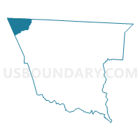
Outline

Summary
| Unique Area Identifier | 665433 |
| Name | Morgan Voting District |
| County | Cherokee County |
| State | South Carolina |
| Area (square miles) | 13.13 |
| Land Area (square miles) | 13.08 |
| Water Area (square miles) | 0.05 |
| % of Land Area | 99.60 |
| % of Water Area | 0.40 |
| Latitude of the Internal Point | 35.16002260 |
| Longtitude of the Internal Point | -81.82626950 |
Maps


Graphs
Select a template below for downloading or customizing gragh for Morgan Voting District, Cherokee County, South Carolina


Neighbors
Neighoring Voting District (by Name) Neighboring Voting District on the Map
- Voting District 05A, Rutherford County, NC
- Voting District 09A, Rutherford County, NC
- Arrowood Baptist Voting District, Spartanburg County, SC
- Ashworth Voting District, Cherokee County, SC
- Chesnee Senior Center Voting District, Spartanburg County, SC
- Ezells-Butler Voting District, Cherokee County, SC
Top 10 Neighboring County Subdivision (by Population) Neighboring County Subdivision on the Map
- High Shoals township, Rutherford County, NC (8,363)
- Macedonia CCD, Cherokee County, SC (7,713)
- Chesnee CCD, Spartanburg County, SC (6,382)
- Mayo CCD, Spartanburg County, SC (5,310)
- Sulphur Springs township, Rutherford County, NC (5,133)
Top 10 Neighboring Place (by Population) Neighboring Place on the Map
Top 10 Neighboring Unified School District (by Population) Neighboring Unified School District on the Map
- Rutherford County Schools, NC (67,810)
- Spartanburg School District 2, SC (58,308)
- Cherokee County School District, SC (53,383)
Top 10 Neighboring State Legislative District Lower Chamber (by Population) Neighboring State Legislative District Lower Chamber on the Map
- State House District 112, NC (75,804)
- State House District 38, SC (37,612)
- State House District 30, SC (34,013)
Top 10 Neighboring State Legislative District Upper Chamber (by Population) Neighboring State Legislative District Upper Chamber on the Map
- State Senate District 46, NC (165,888)
- State Senate District 11, SC (101,438)
- State Senate District 14, SC (98,937)
Top 10 Neighboring 111th Congressional District (by Population) Neighboring 111th Congressional District on the Map
- Congressional District 4, SC (770,226)
- Congressional District 5, SC (767,773)
- Congressional District 11, NC (703,606)
- Congressional District 10, NC (689,468)
Top 10 Neighboring Census Tract (by Population) Neighboring Census Tract on the Map
- Census Tract 9701, Cherokee County, SC (7,713)
- Census Tract 223.02, Spartanburg County, SC (5,310)
- Census Tract 9612, Rutherford County, NC (4,730)
- Census Tract 223.04, Spartanburg County, SC (4,433)
- Census Tract 9611.02, Rutherford County, NC (3,349)
- Census Tract 223.03, Spartanburg County, SC (1,949)